File:Greater Israel Natural Borders.jpeg
Greater_Israel_Natural_Borders.jpeg (711 × 484 pixels, file size: 494 KB, MIME type: image/jpeg)
Captions
Captions
Summary[edit]
| DescriptionGreater Israel Natural Borders.jpeg |
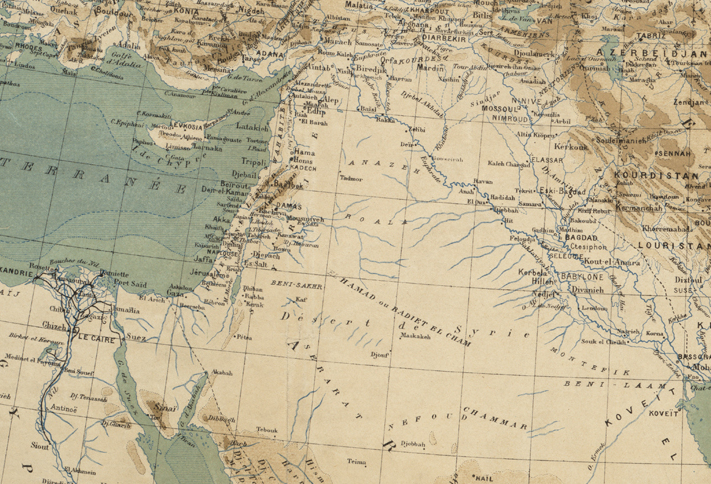
Zoom into this map at maps.bpl.org. Author: Perron, Charles Eugène Publisher: s.n. Date: [1883]. Location: Middle East Scale: Scale 1:9,000,000. Call Number: G7420 1883.P47 |
||||||||||||||||||||
| Date | |||||||||||||||||||||
| Source |
|
||||||||||||||||||||
| Author |
creator QS:P170,Q2959972
|
||||||||||||||||||||
| Other versions |
|
||||||||||||||||||||
Licensing[edit]
- You are free:
- to share – to copy, distribute and transmit the work
- to remix – to adapt the work
- Under the following conditions:
- attribution – You must give appropriate credit, provide a link to the license, and indicate if changes were made. You may do so in any reasonable manner, but not in any way that suggests the licensor endorses you or your use.
File history
Click on a date/time to view the file as it appeared at that time.
| Date/Time | Thumbnail | Dimensions | User | Comment | |
|---|---|---|---|---|---|
| current | 17:28, 10 September 2023 |  | 711 × 484 (494 KB) | Joalbertine (talk | contribs) | File:LAsie antérieure (2675646274).jpg cropped 64 % horizontally, 71 % vertically using CropTool with lossless mode. |
You cannot overwrite this file.
File usage on Commons
The following 2 pages use this file:
Metadata
This file contains additional information such as Exif metadata which may have been added by the digital camera, scanner, or software program used to create or digitize it. If the file has been modified from its original state, some details such as the timestamp may not fully reflect those of the original file. The timestamp is only as accurate as the clock in the camera, and it may be completely wrong.
| Camera manufacturer | Sinar AG |
|---|---|
| Camera model | Sinarback 54 FW, Sinar m |
| Author | Boston Public Library |
| Width | 9,456 px |
| Height | 7,880 px |
| Bits per component |
|
| Compression scheme | Uncompressed |
| Pixel composition | RGB |
| Orientation | Normal |
| Number of components | 3 |
| Horizontal resolution | 300 dpi |
| Vertical resolution | 300 dpi |
| Data arrangement | chunky format |
| Software used | Adobe Photoshop CS3 Macintosh |
| File change date and time | 18:50, 10 July 2008 |
| Color space | Uncalibrated |
| Image width | 2,000 px |
| Image height | 1,667 px |
| Date and time of digitizing | 14:50, 10 July 2008 |
| Date metadata was last modified | 14:50, 10 July 2008 |
| IIM version | 2 |


