

If pictures of Pelorus Bridge look vaguely familiar, it might be because you’ve seen them in a movie! The Pelorus River was used in one of the iconic scenes in The Hobbit: Desolation of Smaug, when the dwarves travelled down the river in barrels. You’ll quickly see why they picked this gorgeous spot with the phenomenal water colour and dramatic cliffs.
Pelorus Bridge is the perfect stop if you’re driving between Picton and Nelson, or a great day trip from either. The emerald river makes for some of the best wild swimming in the area and there are plenty of walking trails too. Tracks range from easy forest strolls to slightly more challenging tracks to waterfalls and lookout points.
We decided to check out the waterfall track as there had been plenty of recent rain, as well as a couple of the short forest walks and swimming spots.
Here’s everything you need to know to plan the perfect half day trip to the Pelorus Bridge Scenic Reserve.

Pelorus Bridge Scenic Reserve
Swimming spots at Pelorus Bridge
The Pelorus River is incredible, with emerald water that has amazing clarity. That is unless you go after heavy rain like we did. The water was no longer crystal clear, so believe me when I say that the photos do not do it justice! If you visit any time other than after heavy rain it is going to be spectacular. As it was, it was still very pretty and very much worth a visit regardless.
As we visited after heavy rain the river was running both high and fast but we’ve heard in summer it can be much calmer and people bring tubes and float along it! You definitely couldn’t have done that when we visited, so if you’re unsure of the conditions you could always give the local DOC office a call and see what it’s like at that time.

Depending on conditions, the river can have a strong current so picking a swimming spot does require care. DOC has marked several swimming spots on the map and these areas have less current (although it was still noticeable).
We initially looked for spots along the Elvy Waterfalls Track, but it was way too wild. The only good spot along this trail would be going for a plunge pool experience at the final waterfall itself - which is a pretty spectacular spot for a dip!
We then opted to check out the Totara Walk which has several swimming spots which are easy to access. The first is the main river access point which is 250m into the walk, but the current was still really strong here and it was quite open and a little less scenic than further along the trail.

Our favourite spot (pictured above) is reached by continuing along the Totara Track for another 200m (450m from the car park) and taking the little path on the left down to the sandy beach. This offered easy water access and the current was less strong.
Just watch out for sandflies because even in early spring they were ferocious and I can only imagine summer is worse! The only protection was being fully submerged in the water - although we didn’t have repellant, so we weren’t really helping ourselves!
I’ve also seen lots of photos of people swimming beside the bridge itself which looks like another great spot. It’s definitely somewhere I’d like to come back to when the water levels are lower and that incredible clarity is back.
Elvy Waterfalls Track
The stats
Distance: 4.3km return
Elevation gained: 125m
Difficulty: Easy
The Elvy Waterfalls Track is an easy track but it does have uneven terrain including rocks and tree roots to walk over. If you’re visiting after heavy rain (which is best for good flow), then you may find that access to the second falls requires removing your boots or getting wet, as the rocks that would normally act as stepping stones can be submerged.
There aren’t really any hills to climb along the trail but there are sections of undulating track.
You could also extend the walk by adding on Trig K Track which branches directly off the Elvy Waterfalls Track, but we wanted to head for a swim so missed it this time.

Starting the trail to the first falls
The walk to the waterfalls begins on the Tawa Track and for the first 600m it’s on a good gravel path and completely flat.
The forest is absolutely beautiful with tall trees keeping it nice and shady and whole rows of majestic tree ferns.
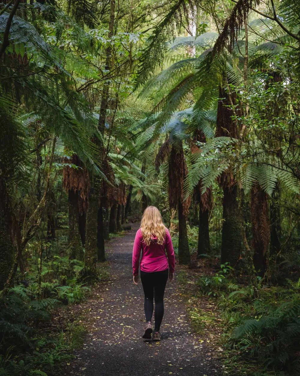
After this point you leave the gravel path and begin following signs for the waterfalls. The path becomes narrower and a little more rugged but it’s not difficult, just less manicured.
You might encounter a little mud if walking after rain but it was never anything major.


Roughly 400m after leaving the smooth gravel path and 1km from the car park you’ll reach the first waterfall.
For us there was really good flow here and it was a lovely spot, it can reduce to a trickle during dry spells though.

To the second waterfall
It’s roughly 1.3km to the second falls from the first, and almost as soon as you leave the first waterfall you’ll start following the river.
The water colour was beautiful even after heavy rain, a definite emerald green. It was raging on our visit with a series of rapids which made it seem impossible that you’d find calm swimming spots further along the river!

The narrow track now snakes its way along the riverbank, always keeping quite high above the water.
It’s a good trail, although rocky in places and a couple of little dips, which were muddy, but again nothing too awful. After 1km you’ll begin descending down towards the second falls and hit a water crossing after 200m.


There are plenty of rocks to act as stepping stones here but all were submerged on our visit. The water was well above ankle level so we opted for a boots off approach.
It’s easy to cross and not very slippery, just fairly icy in early spring! You can either follow the water for the last minute or two to the falls, or climb up and down the bank on the other side.


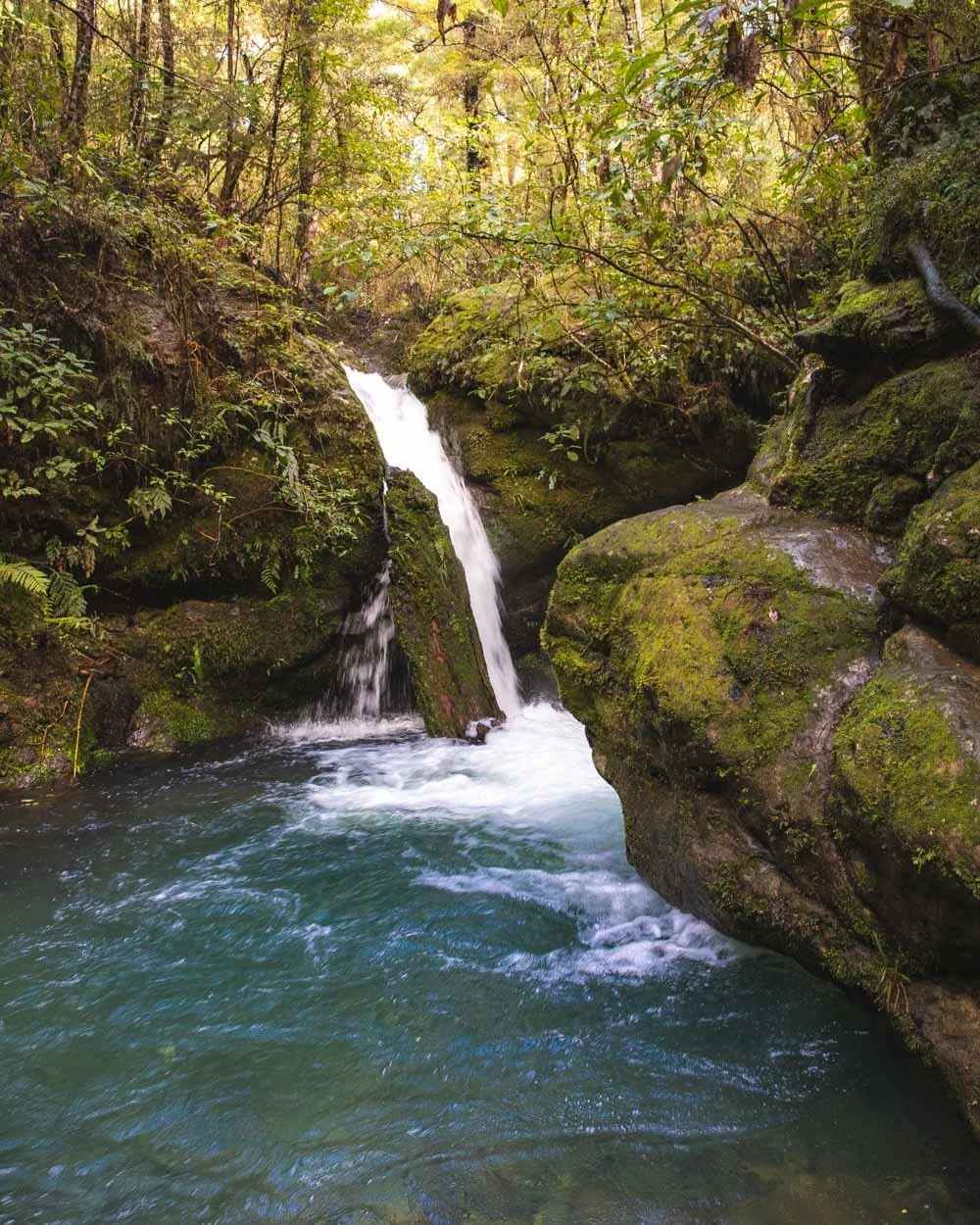
You’ll then be standing on a pebbly area beside the striking waterfall. Unlike the first waterfall this one feels secluded, almost semi hidden in the mossy grotto.
The water was the most beautiful colour we saw in the area (although I think it’s probably similar to how the main river runs when not diluted with heavy rain), almost bluey green and crystal clear. It was exceptionally cold but definitely worth a paddle or a full plunge if you dare!
The walk back
The walk back is easy, you have a little bit of uphill to get back up to the riverbank from the second falls and then it’s very gentle all the way back, mainly flat with some undulations. When we got to the sign post saying that the car park was 500m away, we diverted from the waterfall track to complete the rest of the Tawa loop.
It was actually quicker than the first part of the walk and you got to see another stunning part of the forest with some of the tallest trees we’ve seen in New Zealand.
It’s flat, easy and very much worth it if you’re a forest lover like I am.

The Totara Walk is another short easy loop on great track and also beautiful, but I think the Tawa is probably the pick of the two.
Getting to the Pelorus Bridge Scenic Reserve
The Pelorus Bridge Scenic Reserve is located on SH6, directly on route between Picton and Nelson. It’s just over an hour from Picton and around 50 minutes from Nelson (and the same distance from Blenheim).
There is plenty of free parking across several car parks, as well as flush toilets and a cafe.
This post may contain affiliate links, meaning at no additional cost to you, that we will earn a small commission if you click through and decide to make a purchase. This helps towards the costs of running our website. Thanks for your support.


